Target Audience Determination
GIS IN COMPANY MANAGEMENT
As a tool where location information can be added to manage data, the limits for CBS have now been exceeded. CBS has a very wide framework from defense systems to driverless vehicles, from finding friends to crime prediction.
Based on the applications in our country, we will limit and detail the subject in terms of "target audience detection", "location-based potential measurement", "GeoMarketing", "address management".
CBS is a level of knowledge for company management. It is an investment. It is a difficult subject to learn, it is laborious, it is difficult to find personnel. Its benefits are direct contribution to profitability such as saving time, labor, money, reducing the risk of investment.
The CBS concept is mostly included in company management with the generation change in managers. It is accepted depending on institutionalization. If the investment is not a new initiative of a large group, CBS investment is not made before reaching a certain operational size. The company first tries to solve the operational need within itself, in the beginning. Then it looks for a professional solution.
In the last 3-4 years, it has become inevitable for "all" software developers and database administrators to touch GIS.
Who Uses GIS in the Private Market?
Large GIS projects are being carried out worldwide, especially in areas such as defense, health, education, security, combating poverty, land management, forest management, urban management, hydrology, agriculture, animal husbandry, climate change, and risk calculation.
The use of GIS in the private sector in our country is becoming widespread. It is spreading to the base. It will soon be an indispensable tool in most sectors.
- Retail companies with dealerships, franchises, and branches
- Companies that distribute electricity, water, and gas
- Companies that manage large numbers of customers
- Logistics and cargo companies
- Marketing companies
- Distribution companies
- Companies that transport personnel
- Real estate agents
- Banks and financial institutions
- Insurance companies
- GSM companies
- Telephone and telecom companies
- Advertising companies
- Economy, politics, climate, social research
GIS is used for many different purposes and in many different sectors.
Target Audience and CBS
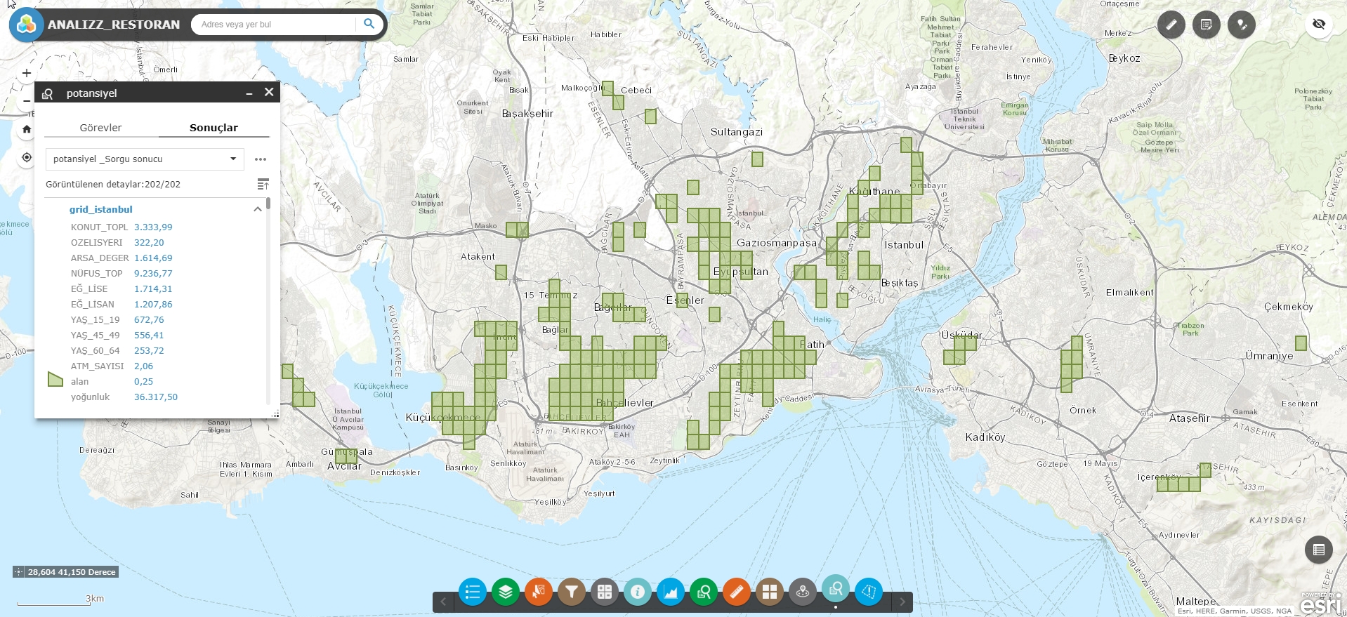
The target audience issue has become a location-based concept with CBS. “Our brand appeals to the upper-income class target audience” is now an incomplete sentence. The answers to the questions of where and when this upper income group goes to buy, where they live, and where they work are sought. It is desired to be closer to this mentioned audience. Where the target audience is concentrated has become as important as its socio-economic characteristics. Once the target audience characteristics are determined, their density and quantity are measured. It can also be tested whether the target audience has been identified correctly.
Socio-Economic Status, or SES or Development level, is an important data for many disciplines. There is a serious problem in our country in this regard. What kind of job does the neighborhood have, how much tax they pay, how much income they have, how many people live in their apartment, whether the house they live in is their own or rented... The last publication date of this information was 2002. This neighborhood-based information has not been published since then. Without this information, investments are made partially blind.
Location-Based Potential Measurement
In which neighborhoods are the people who shop from you concentrated - what is the socio-demography of these neighborhoods? The answer to this question is critical. Places in neighborhoods with similar socio-demographic characteristics but where full potential sales have not yet been made are investment areas. Here, the population density of this demographic, the number of households, the total population and age groups are other potential evaluation elements.
A company with 100 branches has decided to open 20 more branches. Where will these new branches be? Of course, in the regions where the target audience is densest and most numerous. This is a classic GIS analysis. This analysis can be done based on the available data on a street or neighborhood basis. The results of this analysis should be in a format that can be expressed with numerical values, without including personal comments.
Geomarketing and Spatial Workplace Data
Geomarketing is the inclusion of GIS in marketing activities. You should make such a sales and marketing organization that you can reach more customers and make more sales by spending less fuel, less personnel, less vehicles, less time.
In which geographies or neighborhoods do your activities yield better results? Where are the workplaces you target the most, what are their sizes. What is the probability that they will be your customers. In what order should you follow these customers? With which type of vehicle should you go to the field? Which regions are your priority for working in the field? You can answer these questions with GIS tools and analysis.
However, with database management, you can manage online the customers you have reached and become your customers, the customers you have reached and will visit again, the customers you have reached but were rejected, the customers you plan to visit, the customers you can visit but are not aware of their existence. This awareness is developing rapidly.
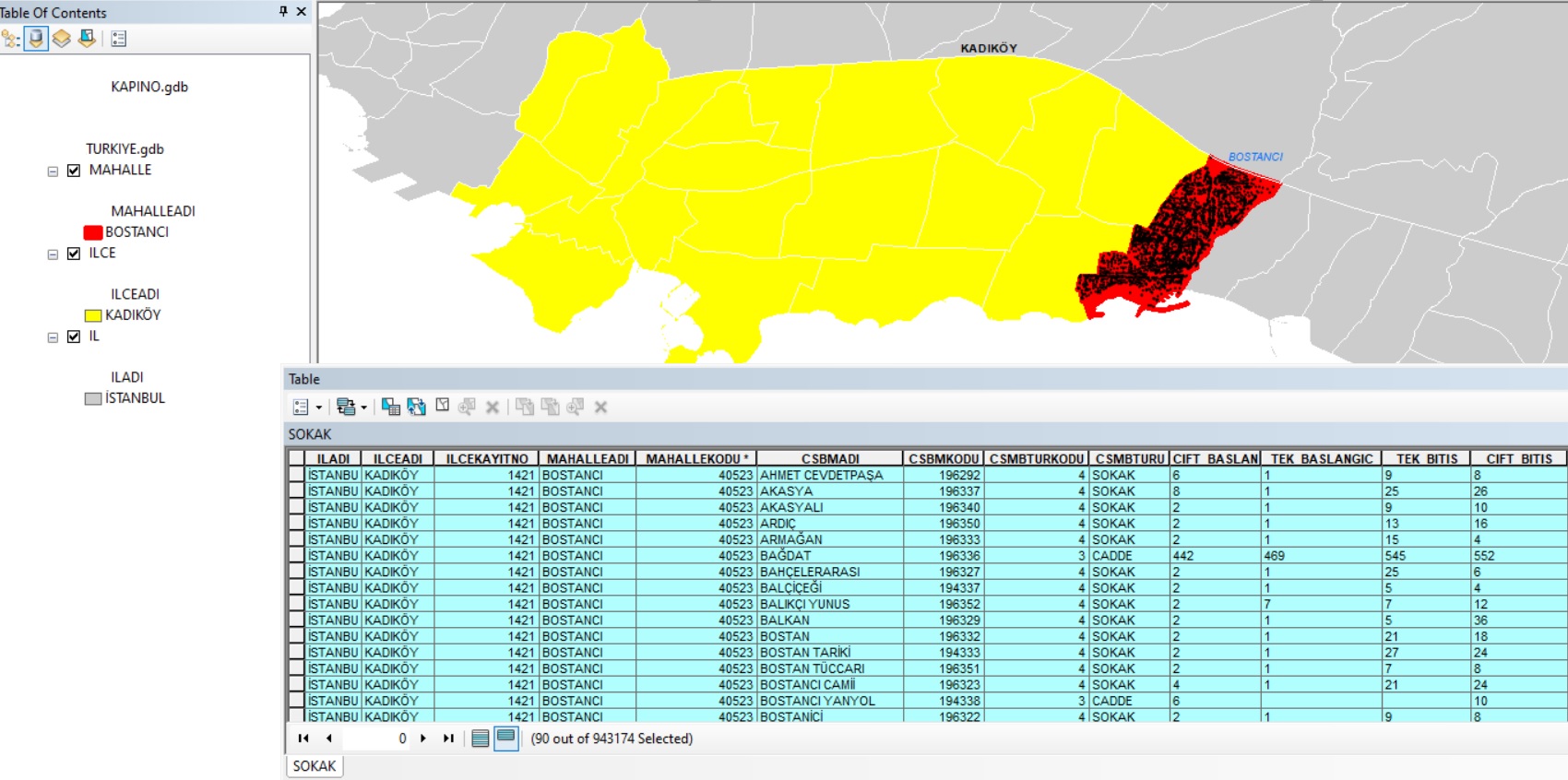
Management of Addresses
There are 1,100,000 streets in our country. This number changes by 5-6% annually.
Even though you no longer write letters to your acquaintances, postal services, especially cargo courier services, are used more and more every day.
Your mailbox is fuller than before (even if you don't look at most of them), couriers knock on your door for packages or documents, motorcycle couriers are very common in big cities.
The volume of e-commerce is increasing day by day. Delivery of basic products such as food and water, dry cleaning and taxi services to the address are now completely location/address based.
The burden that every valuable document, advertisement, pizza, hamburger, courier, box, seizure, cargo, etc. that does not reach its destination brings to our country can easily be measured in millions of dollars. How much does a bank with only 5 million credit card customers lose annually due to irregular addresses?
Cost items of changing the name of a big street: street signs. Door number plates. The need to change all addresses of individuals in institutions and organizations, address chaos in postal and courier companies. Your credit card that does not reach you. The child who brought your lahmacun getting lost…
The main reasons for address irregularities
- The fact that the province-district-municipality-neighborhood/village-street-door number system does not exist throughout the country due to the disordered nature of our cities. The non-existence or incompleteness of the numbering
- Frequent and unplanned changes of elements in this system: technical inadequacies of the institutions that exercise their authority and arbitrary use of authority (the 30-40 year old practice of changing a street name with a person's decision). Individuals and institutions that do not know the importance of the concept of UAVT code.
- Our people not knowing their addresses or not caring about writing them properly
- Company managers who do not understand the importance of the address registration system
- All of us who do not understand the importance of managing the existing address chaos
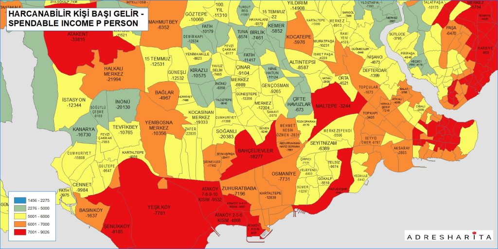
Disposable Income
Regional Analysis
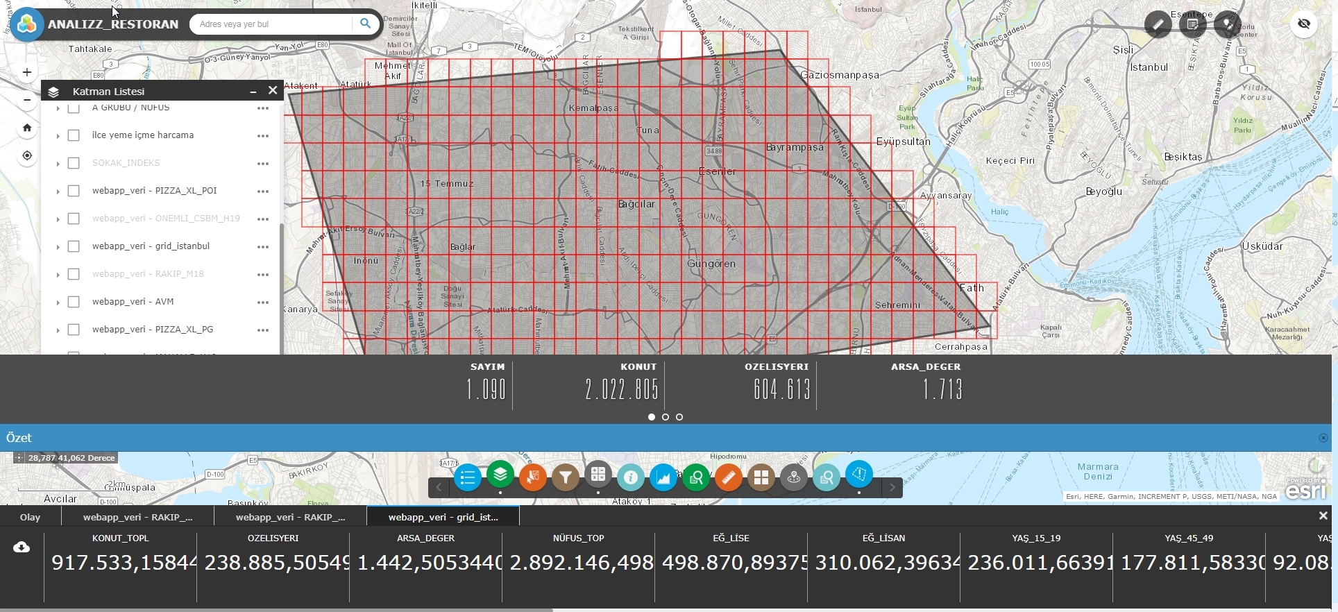
Address Entry with District Neighborhood Street Selection