KUSTEPE
| Adi | KUSTEPE Province Affiliated | SIRNAK District Affiliated | CIZRE Postal code | 73000 Number of Streets | 23 Population Density km2-people | 156.28 Number of Apartments with business Licenses | 14 Number of Apartments with Residential Licenses | 156 Number of Households / Families | 85 Total Population | 526 Male Population | 267 Woman Population | 259 Income Per Person - Spendable TL-Month | 14,423 |
|---|
KUSTEPE Neighbourhood Map | All Neighbourhoods and Settlements
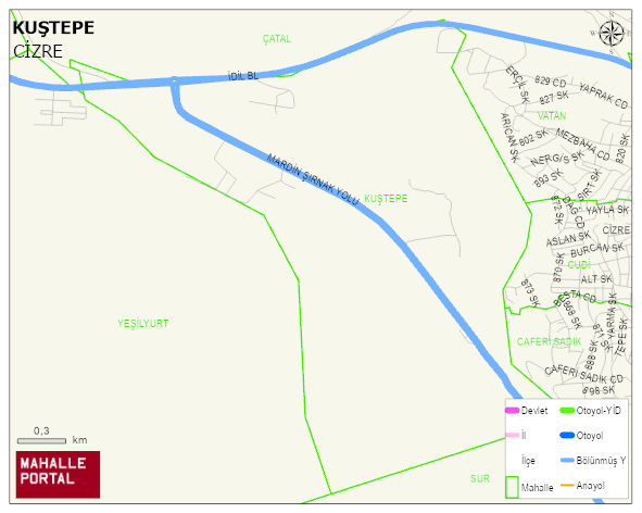
KUSTEPE Neighbourhood Digital Map | Geography and Natural Features
KUSTEPE Neighbourhood – Population, Postal Code, Number of Workplaces
KUSTEPE neighborhood is located in CIZRE district of SIRNAK province. UAVT (National Address Database Code) Neighborhood Code: 484576. Postal Code: 73000. The population density is -per square kilometer- 139 people. KUSTEPE 23 streets and avenues, 12 independent business licensed apartments, 137 residential licensed apartments, 79 households. 469 people live in this settlement. 233 male, 236 female. 60 and over is 15. The population rate of 60+ people is % 3 and the ratio of children under the age of 10 to the population is % 30 En genç 400 mahalle ve köyden biridir. (Nüfusu 250den büyük 29000 köy ve mahalle içinde)
KUŞTEPE Mahallesi
KUŞTEPE Mahallesi için merak uyandıran başlıklar:
- 👥 Kimler yaşıyor? Nüfus, yaş, eğitim
- 🌍 Zemin sağlam mı? Fay hattı, deprem, rakım
- 🌱 Doğa & şehir dengesi Yeşil alan, tarım, konut
- ☀️ Hava nasıl? Sıcaklık, yağış
Kısa başlıklar ama bolca fikir: KUŞTEPE Mahallesi’i keşfetmek için ideal!
KUSTEPE Neighbourhood Meteorological Statistics > Climate
| Avg Temperature (°C) | 18.02 |
|---|---|
| Min Temperature (°C) | -9.13 |
| Rainfall amount (cm/day) | 4.30 |
| Snowfall amount (cm/day) | 0.12 |
KUSTEPE Neighbourhood Number of Singles | Number of Widows
KUŞTEPE Mahallesi 2024 Yerel Seçim Katılım ve Oy Dağılımı
KUŞTEPE Mahallesi ilçesinde 2024 yerel seçimlerinde (belediye başkanlık seçimi, mahalli idareler seçimi) aday oy oranları, katılım bilgileri, seçmen tercihleri ve belediye başkanlık sonuçları ayrıntılı şekilde sunulmaktadır.
KUSTEPE Neighbourhood Mayoral Election
KUSTEPE Neighbourhood Number of Voters in the Mayoral Election
| Party | Votes |
|---|---|
| Neighborhood - Village | KUSTEPE MAH. |
| Number of Voters | 249 |
| Total Independent Votes | 0 |
| Number of Valid Votes | 212 |
KUSTEPE Neighbourhood Provincial Council Election| 2024
KUSTEPE Neighbourhood Number of Voters in the MProvincial Council Election | 2024
| Party | Votes |
|---|---|
| Neighborhood - Village | KUSTEPE MAH. |
| Number of Voters | 249 |
| Total Independent Votes | 0 |
| Number of Valid Votes | 214 |
KUSTEPE Neighbourhood Municipal Council Election
KUSTEPE Neighbourhood Number of Voters in the Municipal Council Election | 2024
| Party | Votes |
|---|---|
| Neighborhood - Village | KUSTEPE MAH. |
| Number of Voters | 249 |
| Total Independent Votes | 0 |
| Number of Valid Votes | 213 |
KUŞTEPE Mahallesi Milletvekili Seçim Sonuçları 2023
2023 Parlamento (TBMM) Seçimleri kapsamında KUŞTEPE Mahallesi için oy dağılımları, parti performansları, meclis sandalye dağılımı ve Türkiye Büyük Millet Meclisi profili yer almaktadır.
KUŞTEPE Mahallesi 2023 Cumhurbaşkanlığı İstatistikleri ve Raporu
2023 Cumhurbaşkanlığı Seçimleri KUŞTEPE Mahallesi için yapılan 1. ve 2. tur oylamalarda adayların oy oranları, katılım verileri ve Beştepe’ye gidecek isim analiz edilmektedir. Bu seçim devletin en üst makamı için yapılmıştır.