GAZILER
| Adi | GAZILER Province Affiliated | GÜMÜSHANE District Affiliated | MERKEZ Postal code | 29020 Number of Streets | 17 Population Density km2-people | 383.76 Number of Apartments with business Licenses | 5 Number of Apartments with Residential Licenses | 268 Number of Households / Families | 226 Total Population | 1663 Male Population | 914 Woman Population | 749 Income Per Person - Spendable TL-Month | 12,942 |
|---|
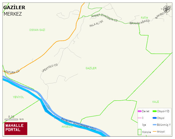
ARZULARKABAKÖY BELDESI GAZILER Neighbourhood Map | Terrain and Topography
GAZILER Neighbourhood Digital Map | Satellite View and Local Boundaries
GAZILER Neighbourhood – Population, Postal Code, Number of Workplaces
GAZILER - ARZULARKABAKÖY neighborhood is located in ARZULARKABAKÖY beldesi MERKEZ district of GÜMÜSHANE province. UAVT (National Address Database Code) Neighborhood Code: 99284. Postal Code: 29020. The population density is -per square kilometer- 90 people. GAZILER - ARZULARKABAKÖY 16 streets and avenues, 5 independent business licensed apartments, 268 residential licensed apartments, 138 households. 392 people live in this settlement. 213 male, 179 female. 60 and over is 74. The population rate of 60+ people is % 18 and the ratio of children under the age of 10 to the population is % 9
GAZİLER Mahallesi
GAZİLER Mahallesi için merak uyandıran başlıklar:
- 👥 Kimler yaşıyor? Nüfus, yaş, eğitim
- 🌍 Zemin sağlam mı? Fay hattı, deprem, rakım
- 🌱 Doğa & şehir dengesi Yeşil alan, tarım, konut
- ☀️ Hava nasıl? Sıcaklık, yağış
Kısa başlıklar ama bolca fikir: GAZİLER Mahallesi’i keşfetmek için ideal!
GAZILER Neighbourhood Green Area, Housing, Commercial and Production Area Statistics
GAZILER Neighbourhood Physical Condition and Risks
| Earthquake acceleration rate -PGA 475 | 0.18 |
|---|---|
| Ground Disturbance Degree -4 | 1 |
| Broken Ground Ratio | 40 |
| Gas Stations | 0 |
| GÜMÜSHANE-BAYBURT AIRPORT DISTANCE -m | 18,002 |
| Distance to Fault Line (m) | 34,231 |
| Lowest Altitude (m) | 1,392 |
| Highest Altitude (m) | 1,769 |
| Avg Altitude (m) | 1,548 |
GAZILER Neighbourhood Meteorological Statistics > Climate
| Avg Temperature (°C) | 5.05 |
|---|---|
| Min Temperature (°C) | -22.79 |
| Rainfall amount (cm/day) | 3.03 |
| Snowfall amount (cm/day) | 0.80 |
GAZILER Neighbourhood | Residents come from which city? | Registry statistics of the inhabitants
| PROVINCE | POPULATION |
|---|---|
| GÜMÜSHANE | 516 |
| TRABZON | 28 |
| ERZURUM | 14 |
| ADIYAMAN | 13 |
| ISTANBUL | 12 |
| KAYSERI | 11 |
| ORDU | 10 |
| BITLIS | 9 |
| SAMSUN | 8 |
| KOCAELI | 7 |
GAZILER Neighbourhood Number of Singles | Number of Widows
GAZILER Neighbourhood Number of University Graduates | Education Statistics
Leave a Comment
IMPORTANT PLACES
STREETS
BOZKURT SOKAK
DÖLEK DERESİ SOKAK
GAZİ İBRAHİM ETHEM SOKAK
GAZİ MEHMET YAKUT SOKAK
GAZİ ŞÜKRÜ ŞENEL SOKAK
GAZİ YUSUF YILDIZ SOKAK
GAZİLER SOKAK
GÖLET YOLU SOKAK
HAFIZ AHMET EZBER SOKAK
İSTİKLAL GAZİSİ TAYFUR DAL SOKAK
KURALLAR SOKAK
NEZAKET ANA SOKAK
ÖĞRETMEN KEMAL ÇELİK SOKAK
ŞEHİT CENGİZ ERKAN SOKAK
ŞEHİT HANEFİ MUTLU CADDE
YAMAÇ SOKAK